Public Use Microdata Areas (PUMAs) are non-overlapping, statistical geographic areas that partition each state or equivalent entity into geographic areas containing no fewer than 100,000 people each. They cover the entirety of the United States, Puerto Rico, Guam, and the U.S. Virgin Islands. The Census Bureau defines PUMAs for the tabulation and dissemination of decennial census and American Community Survey (ACS) Public Use Microdata Sample (PUMS) data. Additionally, the ACS and Puerto Rico Community Survey use them to disseminate their respective period estimates.
PUMA boundaries are redrawn after each decade with input from the states through the State Data Centers.
The ACS and Census microdata allows data users to create custom estimates and tables that are not available through pretabulated data products. Some variable values are grouped in the pretabulated data, but have more detail in the microdata, like income, language spoken at home, etc. The microdata also allows for all kinds of cross-tabulations, within household connections, etc.
There are two websites that allow for custom tabulations and extracts of the microdata:
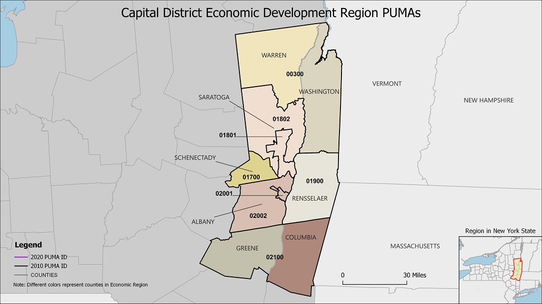
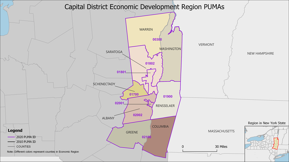
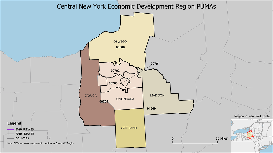
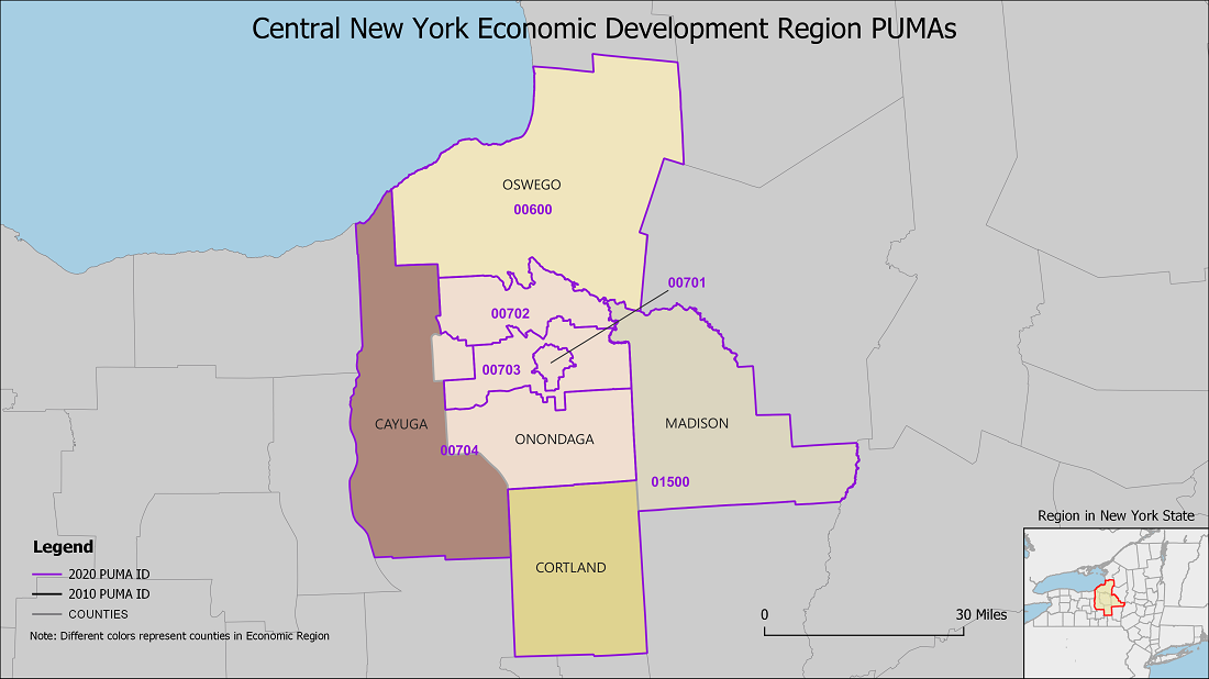
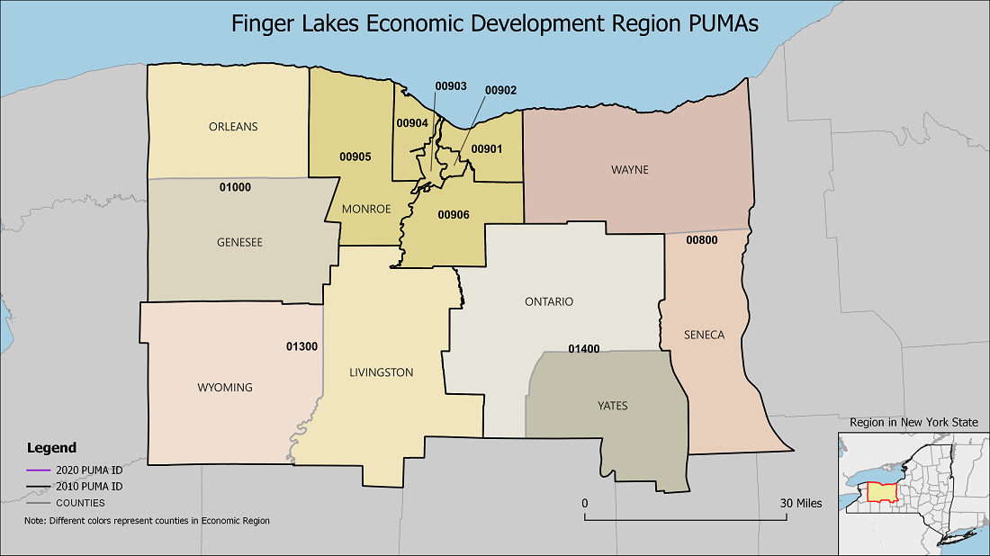
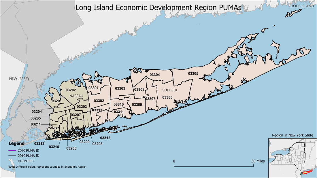
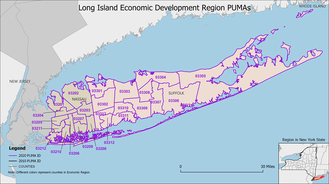
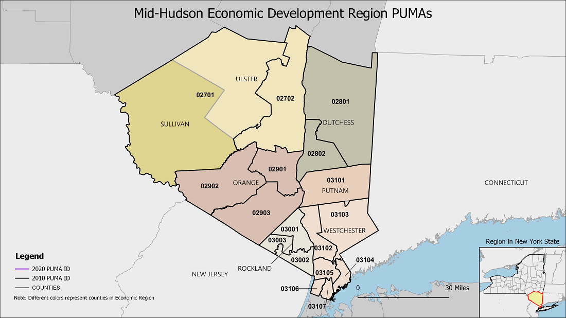
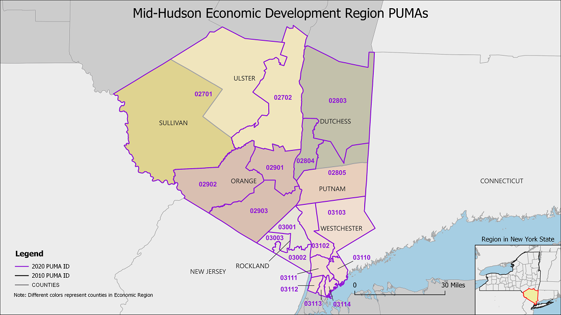
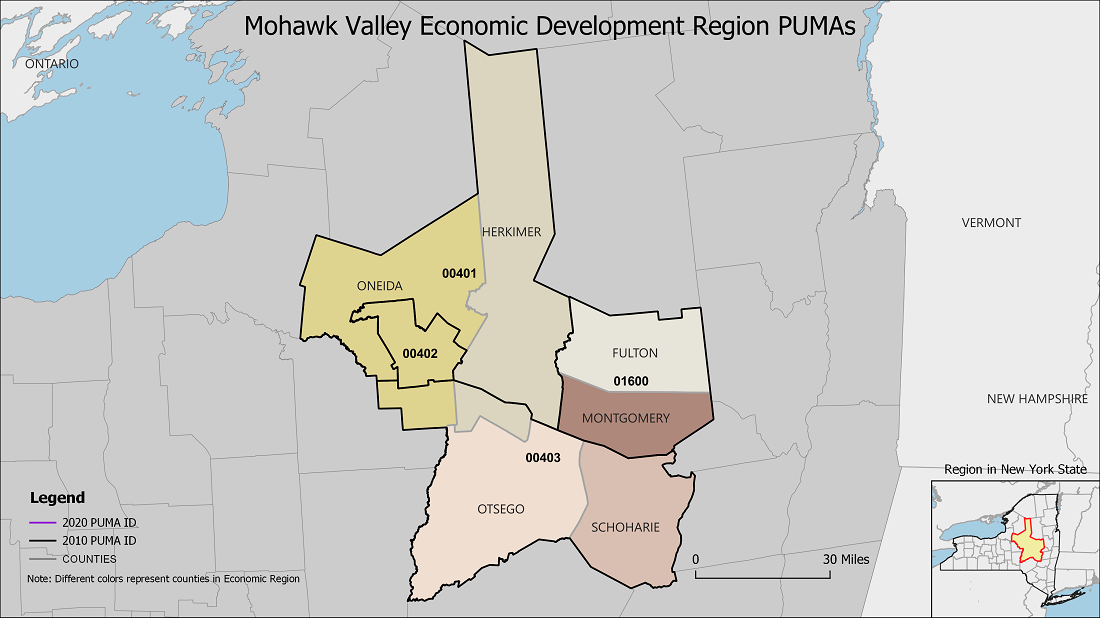
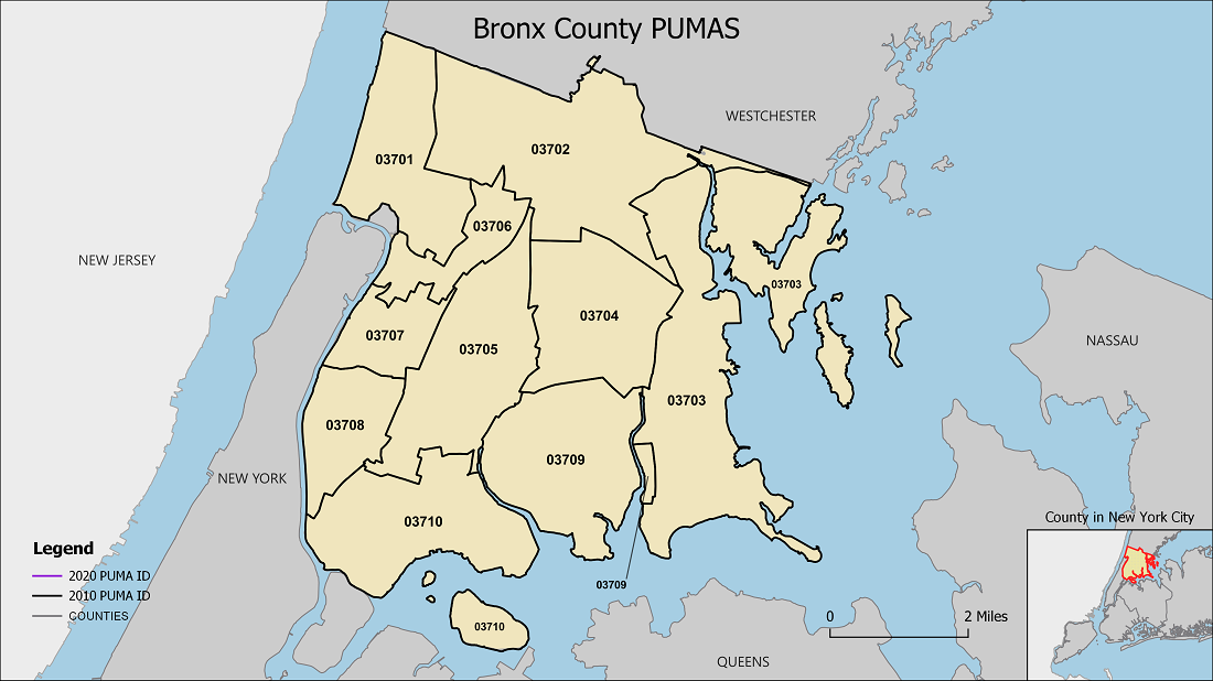
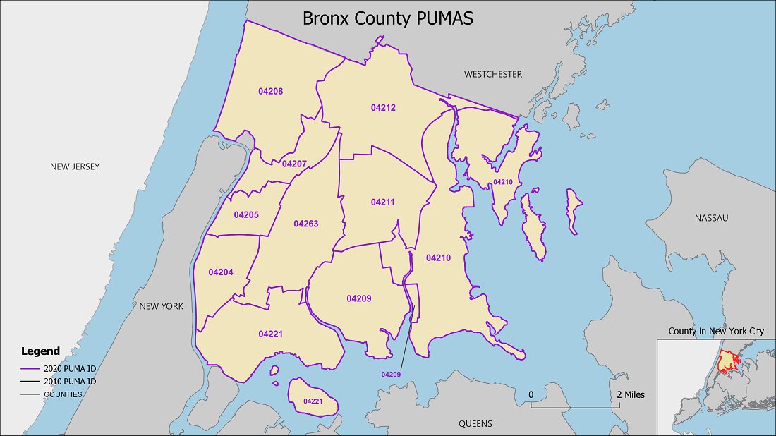
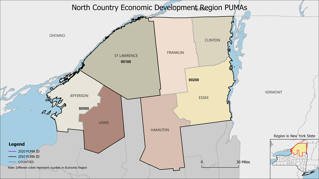
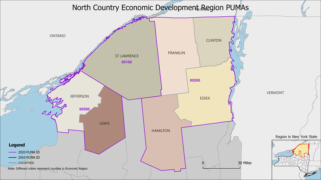
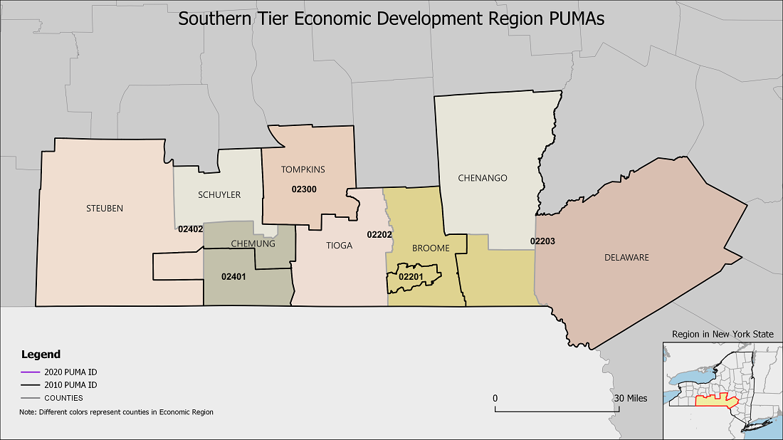
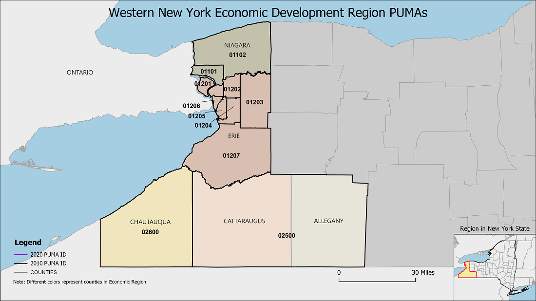
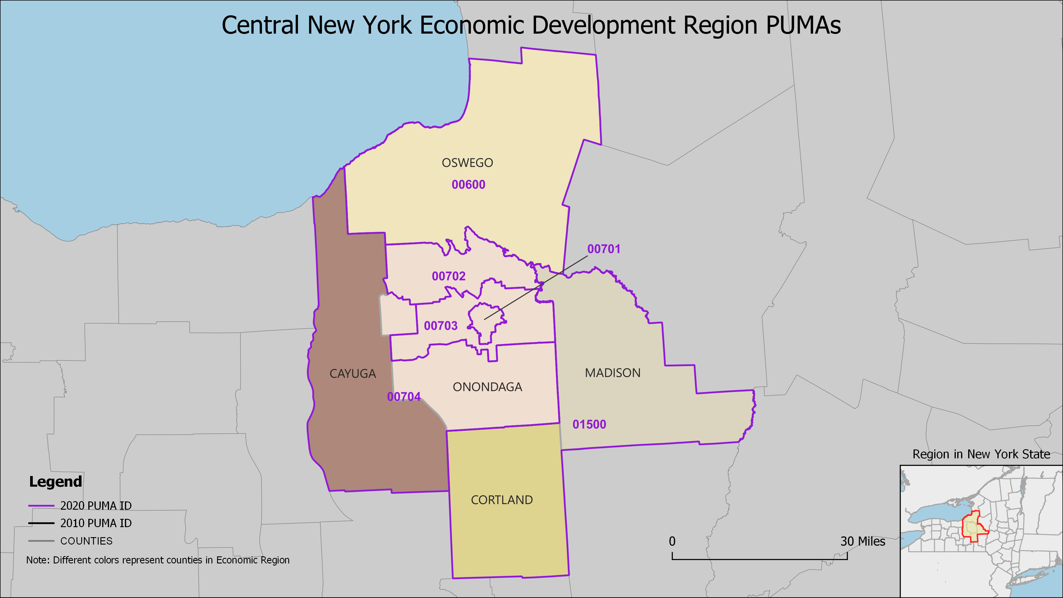
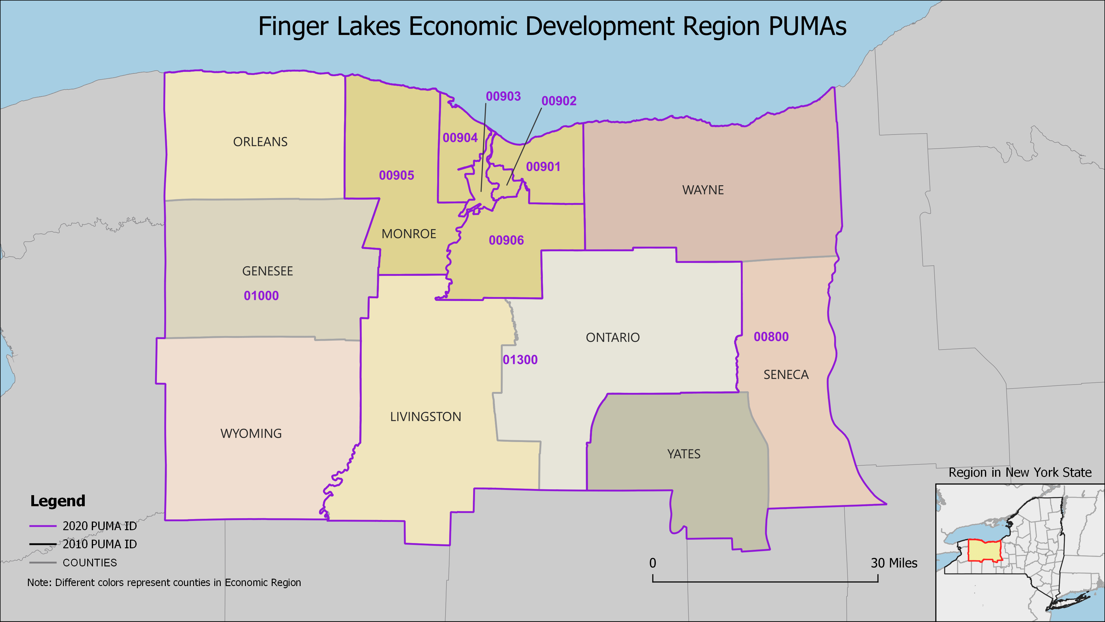
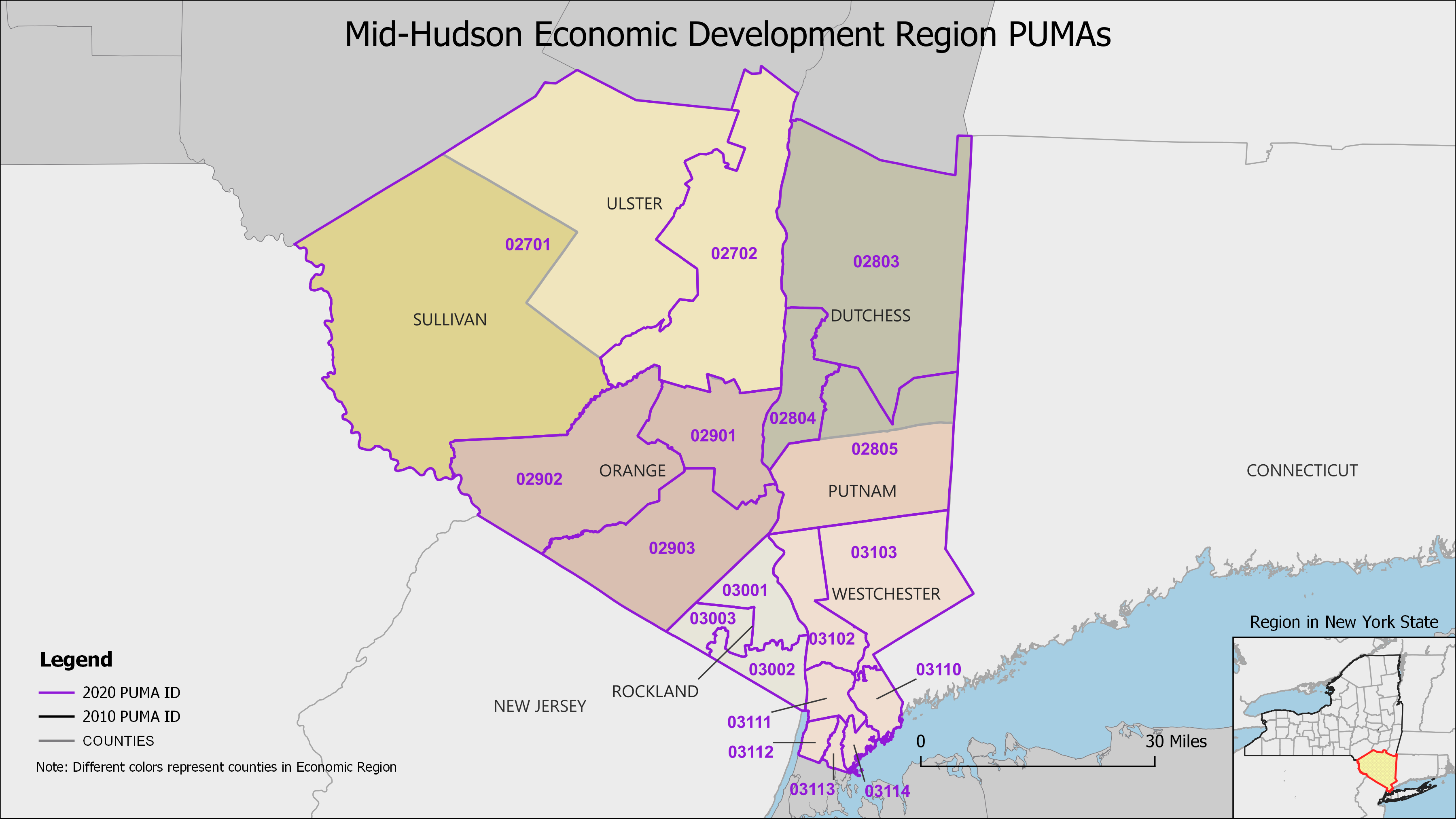
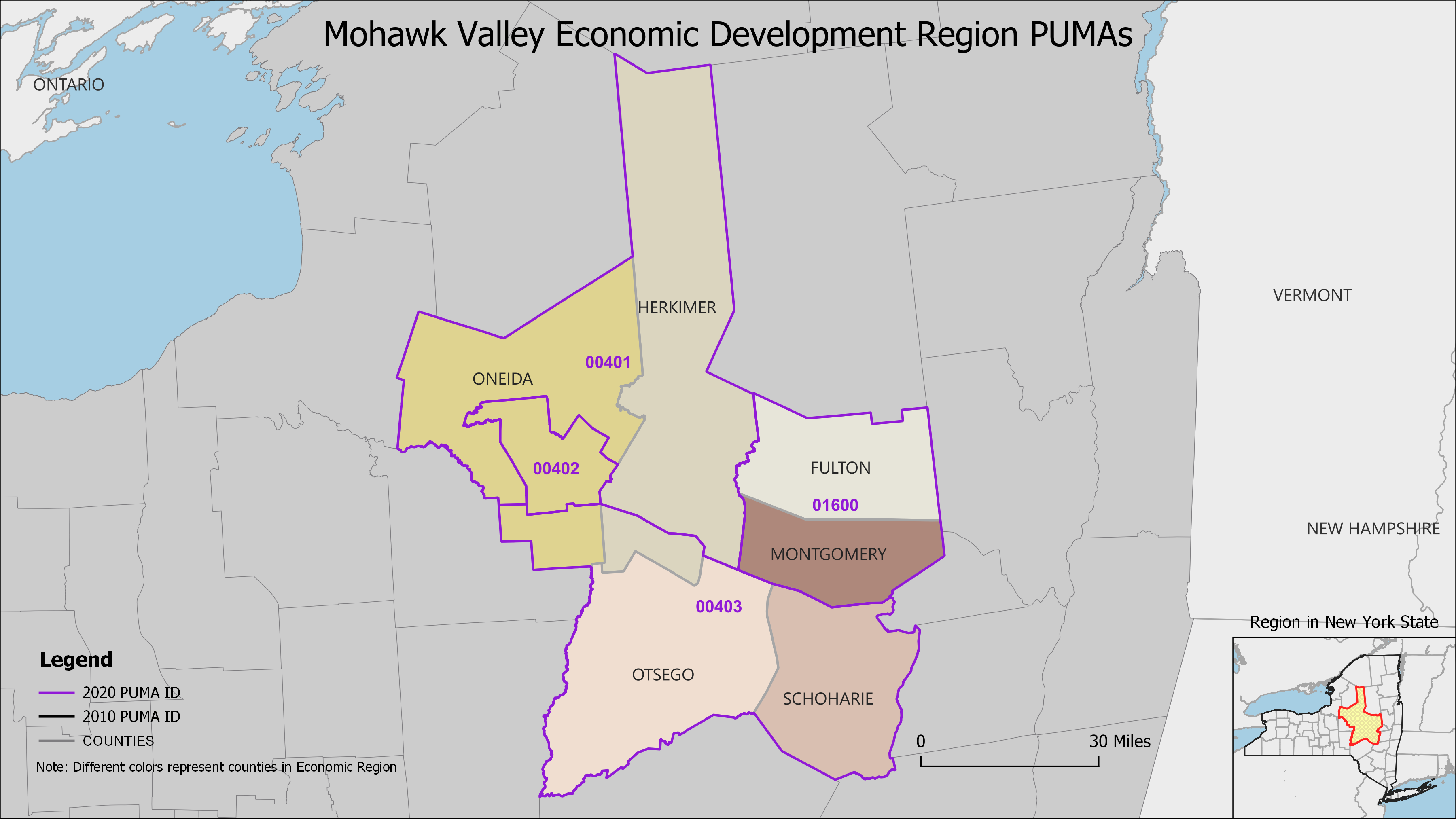
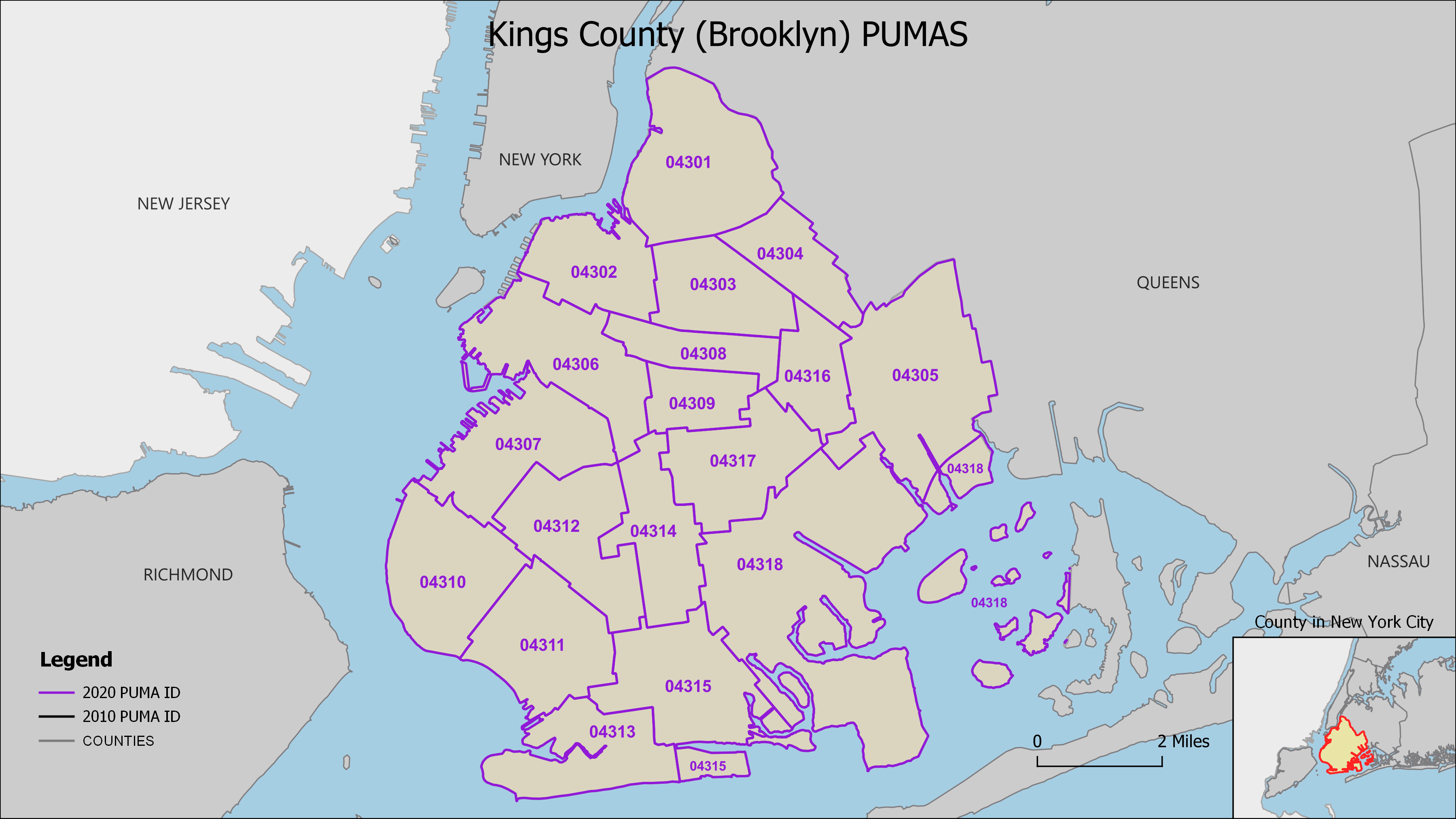
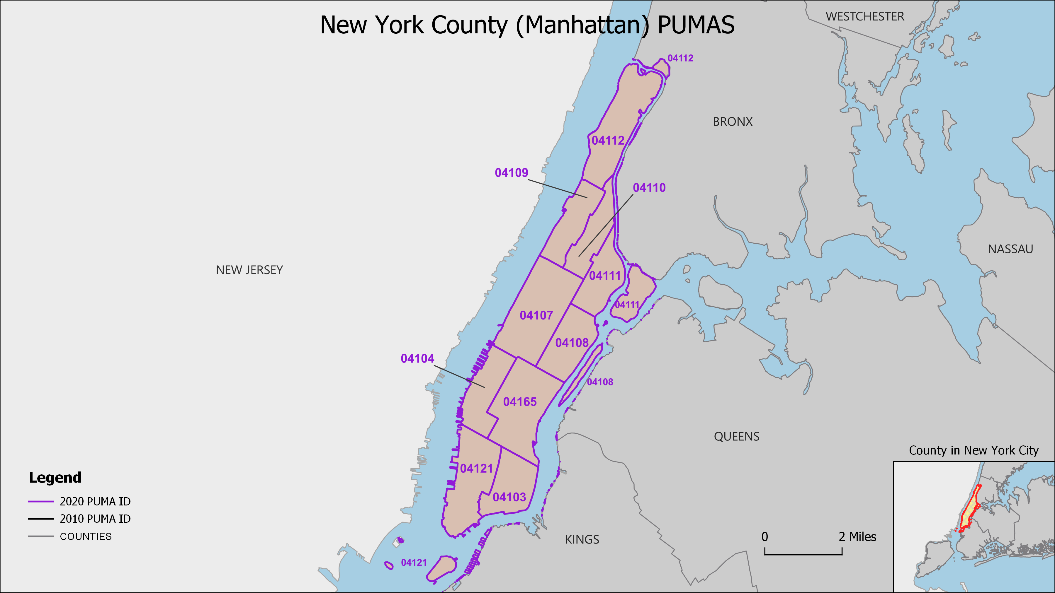
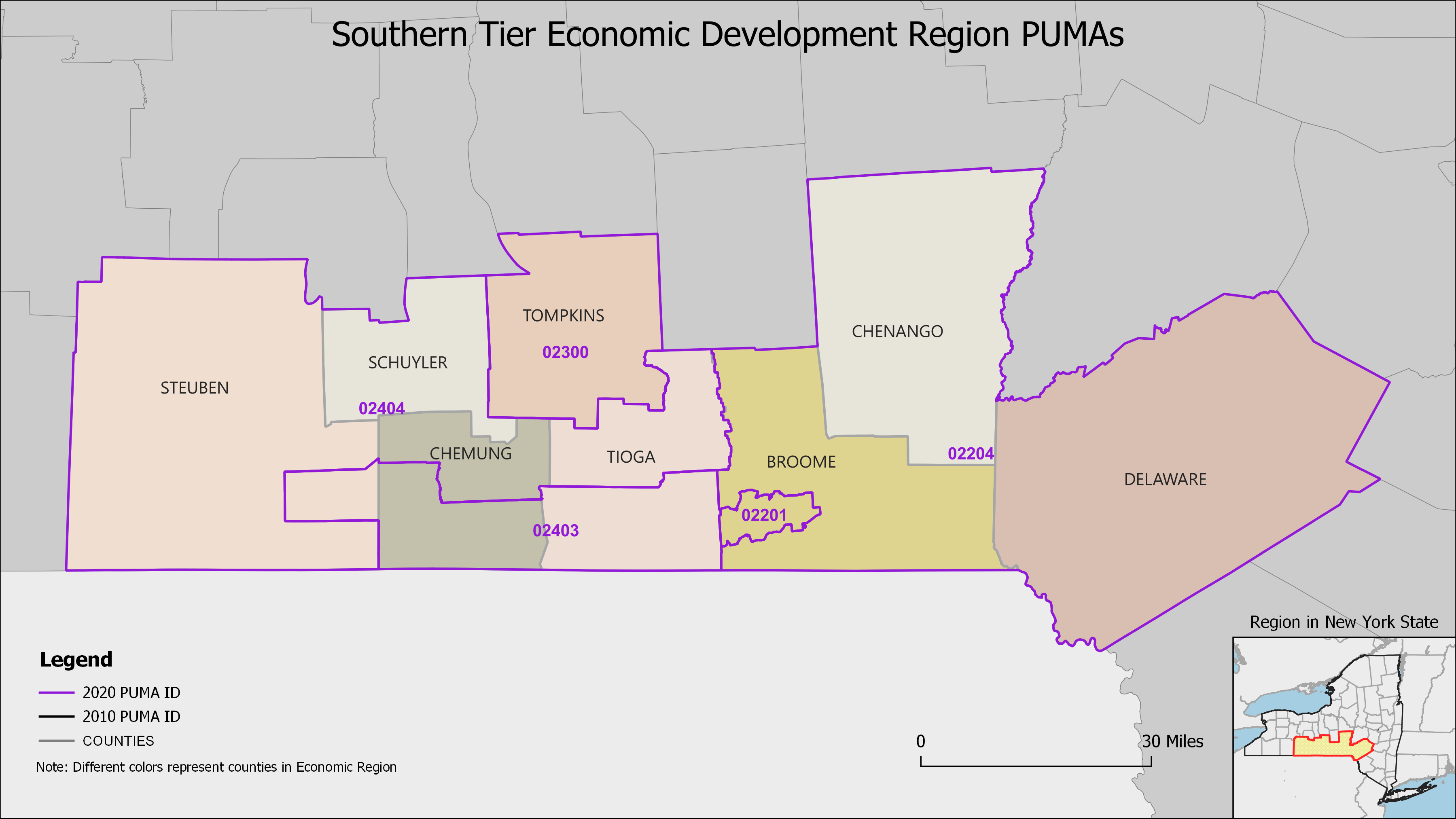
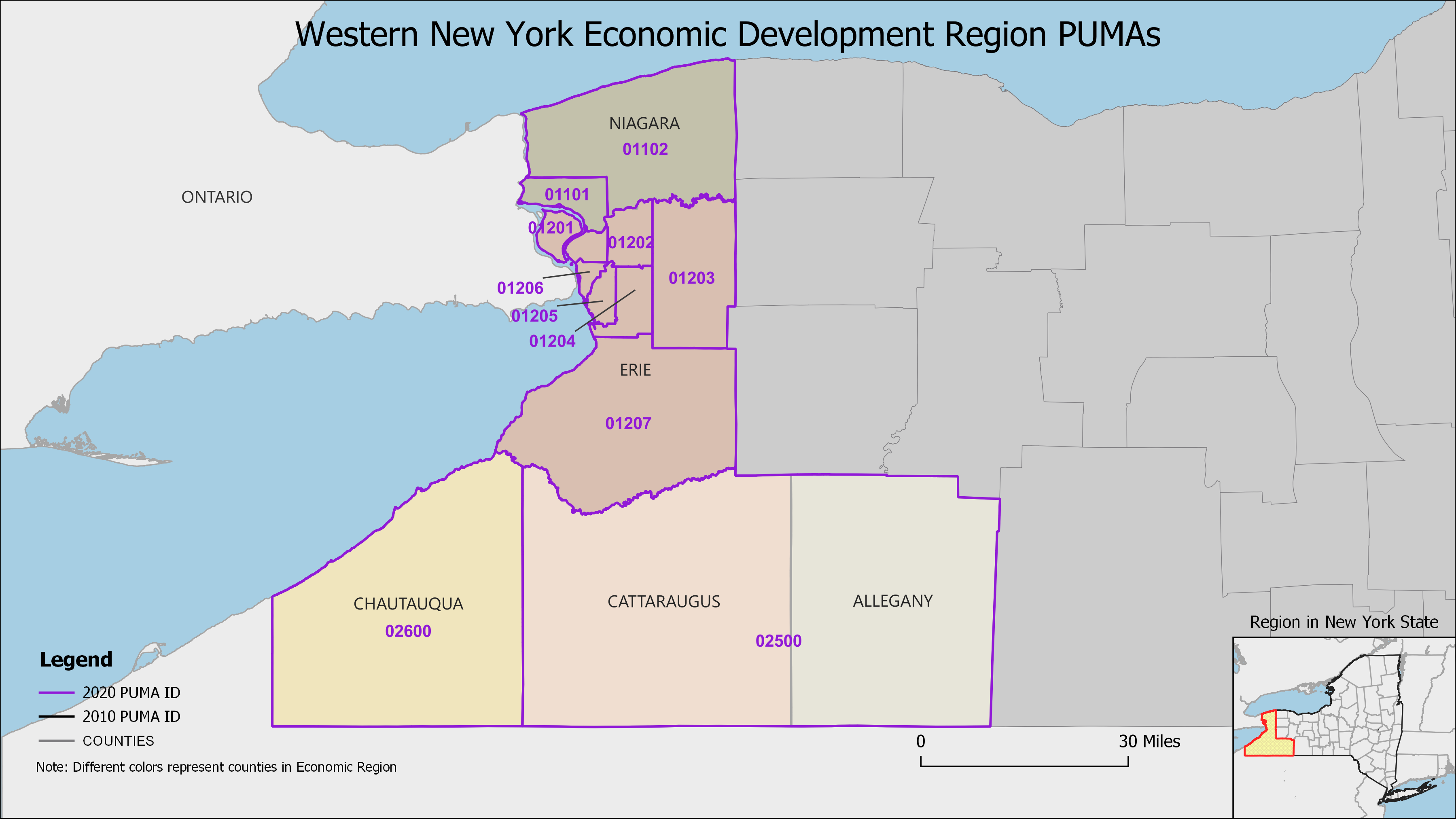
In New York State the PUMAs are delineated within each of the 10 state defined economic regions. These regions are listed on the left and after selecting a region the PUMAs for that region will be presented. The PUMAs in New York City are presented by borough.
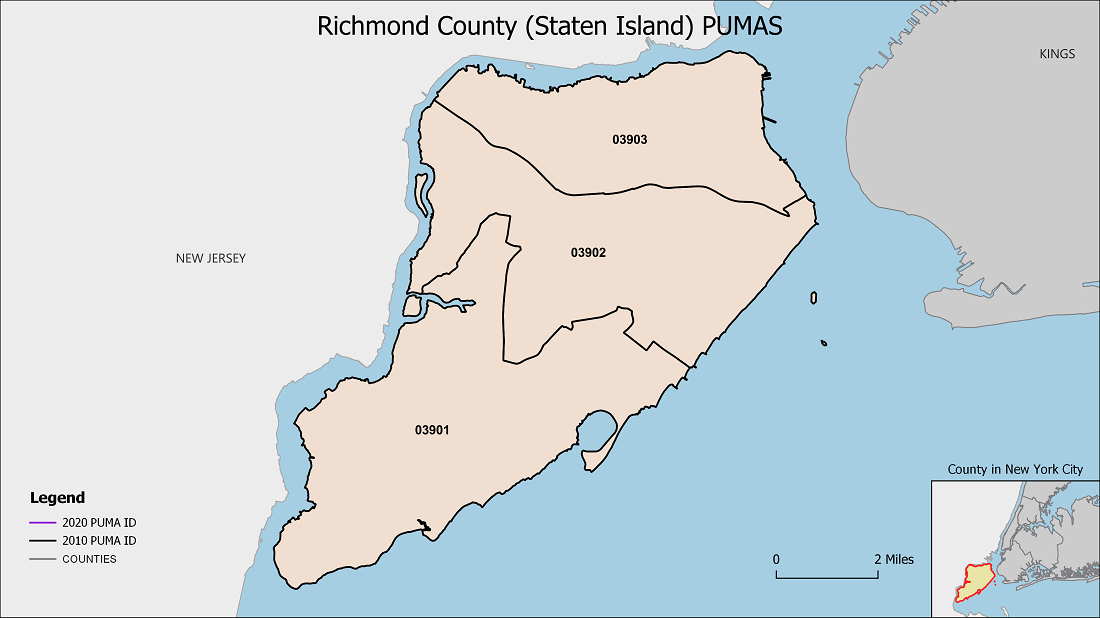
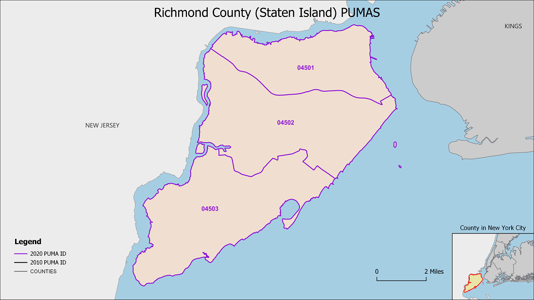
The 2020 PUMAs are presented on top of the 2010 PUMAs and a slider enables the viewer to see the differences between the old and the new delineations. Move the slider to the left to see the 2020 map and to the right to see the old 2010 PUMA map.
Under the map is a button to download the 2020 PUMA map in a higher resolution. There is also a table with the 2020 PUMA IDs, the 2020 names and population and housing unit counts from the 2020 Census.
| PUMA ID | Name | Population 2020 | Housing Units 2020 |
|---|---|---|---|
| 00300 | Warren & Washington Counties | 127,039 | 68,926 |
| 01700 | Schenectady County--Schenectady City | 158,061 | 70,794 |
| 01801 | Saratoga County (South & Central) | 115,247 | 54,520 |
| 01802 | Saratoga County (Outer) | 120,262 | 55,399 |
| 01900 | Rensselaer County--Troy City | 161,130 | 74,197 |
| 02001 | Albany County (East Central)--Albany City | 107,800 | 52,220 |
| 02002 | Albany County (Outside Albany City) | 207,048 | 93,911 |
| 02100 | Columbia & Greene Counties | 109,501 | 62,152 |
| PUMA ID | Name | Population 2020 | Housing Units 2020 |
|---|---|---|---|
| 00600 | Oswego County | 117,525 | 54,470 |
| 00701 | Onondaga County (Central)--Syracuse City | 148,626 | 66,797 |
| 00702 | Onondaga County (North) | 128,516 | 55,683 |
| 00703 | Onondaga County (Central)--Syracuse City (Outer) | 164,828 | 72,766 |
| 00704 | Cayuga & Onondaga (South) Counties | 110,794 | 52,757 |
| 01500 | Madison & Cortland Counties | 114,825 | 51,365 |

| PUMA ID | Name | Population 2020 | Housing Units 2020 |
|---|---|---|---|
| 00800 | Wayne & Seneca & Yates Counties | 149,871 | 71,390 |
| 00901 | Monroe County (East) | 136,023 | 60,237 |
| 00902 | Monroe County (Central)--Rochester City (East) | 105,871 | 52,871 |
| 00903 | Monroe County (Central)--Rochester City (West) | 105,242 | 47,107 |
| 00904 | Monroe County (Central)--Greece & Gates Towns | 126,093 | 56,324 |
| 00905 | Monroe County (North & West) | 104,966 | 44,068 |
| 00906 | Monroe County (South) | 181,248 | 75,655 |
| 01000 | Genesee, Orleans & Wyoming Counties | 139,262 | 62,408 |
| 01300 | Livingston & Ontario Counties | 174,292 | 79,698 |
| PUMA ID | Name | Population 2020 | Housing Units 2020 |
|---|---|---|---|
| 03201 | Nassau County (Northwest)--North Hempstead Town (North) | 118,149 | 43,410 |
| 03202 | Nassau County (Northeast)--Oyster Bay Town (North) & Glen Cove City | 114,990 | 41,506 |
| 03203 | Nassau County (East Central)--Oyster Bay Town (Central) | 106,221 | 35,987 |
| 03204 | Nassau County (West Central)--North Hempstead Town (South) | 119,490 | 40,319 |
| 03205 | Nassau County (West Central)--Hempstead Town (Northwest) | 118,668 | 38,524 |
| 03206 | Nassau County (Central)--Hempstead Town (North Central)--Meadowbrook Corridor | 154,180 | 43,787 |
| 03207 | Nassau County (Central)--Hempstead Town (Northeast) | 114,103 | 38,462 |
| 03208 | Nassau County (Southeast)--Oyster Bay Town (South) | 108,486 | 38,215 |
| 03209 | Nassau County (Central)--Hempstead Town (East Central) | 105,022 | 36,154 |
| 03210 | Nassau County (South Central)--Hempstead Town (Southeast) | 109,227 | 39,281 |
| 03211 | Nassau County (West Central)--Hempstead Town (West Central) | 115,026 | 37,888 |
| 03212 | Nassau County (Southwest)--Hempstead Town (Southwest) & Long Beach City | 112,212 | 43,199 |
| 03301 | Suffolk County (Northwest)--Huntington Town (North) | 101,400 | 36,987 |
| 03302 | Suffolk County (Northwest)--Huntington Town (South) | 102,727 | 36,086 |
| 03303 | Suffolk County (Northwest)--Smithtown Town | 116,296 | 41,415 |
| 03304 | Suffolk County (North Central)--Brookhaven Town (North) | 118,528 | 42,376 |
| 03305 | Suffolk County (East) | 161,127 | 99,096 |
| 03306 | Suffolk County (South Central)--Brookhaven Town (South) | 133,185 | 50,461 |
| 03307 | Suffolk County (Central)--Brookhaven Town (Central) | 125,701 | 48,250 |
| 03308 | Suffolk County (Central)--Brookhaven Town (West Central) | 108,795 | 37,653 |
| 03309 | Suffolk County (Central)--Islip Town (East) | 102,493 | 38,776 |
| 03310 | Suffolk County (Central)--Islip Town (Northwest) | 130,712 | 33,014 |
| 03311 | Suffolk County (Southwest)--Islip Town (South) | 106,733 | 39,556 |
| 03312 | Suffolk County (Southwest)--Babylon Town (Southeast) | 101,006 | 36,429 |
| 03313 | Suffolk County (West Central)--Babylon Town (Northwest) | 117,217 | 38,841 |
| PUMA ID | Name | Population 2020 | Housing Units 2020 |
|---|---|---|---|
| 02701 | Sullivan & Ulster (West) Counties | 112,760 | 69,228 |
| 02702 | Ulster County (East) | 147,715 | 65,750 |
| 02803 | Dutchess County (North & East) | 114,933 | 48,740 |
| 02804 | Dutchess County (Southwest)--Fishkill & Wappinger town | 143,259 | 58,922 |
| 02805 | Putnam County & Southern Dutchess County | 135,387 | 52,655 |
| 02901 | Orange County (Northeast)--Greater Newburgh City | 124,926 | 48,846 |
| 02902 | Orange County (Northwest) | 129,612 | 50,166 |
| 02903 | Orange County (Southeast) | 146,772 | 47,867 |
| 03001 | Rockland County (North)--New City & Congers | 106,384 | 36,834 |
| 03002 | Rockland County (South)--Orangetown, Clarkstown (South) & Ramapo (Southeast) Towns | 109,337 | 38,836 |
| 03003 | Rockland County (West)--Spring Valley, Suffern Villages & Monsey | 122,608 | 32,398 |
| 03102 | Westchester County (Northwest) | 152,473 | 56,889 |
| 03103 | Westchester County (Northeast) | 139,687 | 53,000 |
| 03110 | Westchester County (Southeast)--White Plains & Rye City | 146,109 | 55,583 |
| 03111 | Westchester County (Central) | 113,650 | 43,312 |
| 03112 | Westchester County (Southwest)--Yonkers City | 211,569 | 85,528 |
| 03113 | Westchester County (South Central East)--Mount Vernon City | 121,612 | 49,250 |
| 03114 | Westchester County (South Central West)--New Rochelle City | 119,357 | 45,401 |

| PUMA ID | Name | Population 2020 | Housing Units 2020 |
|---|---|---|---|
| 00401 | Herkimer (North & Central) & Oneida (Outer) Counties | 109,807 | 56,835 |
| 00402 | Oneida County (Central)--Greater Utica & Rome Cities | 164,365 | 72,436 |
| 00403 | Otsego, Schoharie, Oneida (South) & Herkimer (South) Counties | 106,330 | 54,270 |
| 01600 | Fulton & Montgomery Counties | 102,856 | 50,944 |
| PUMA ID | Name | Population 2020 | Housing Units 2020 |
|---|---|---|---|
| 04204 | NYC-Bronx Community District 4--Highbridge & Concourse | 151,523 | 54,431 |
| 04205 | NYC-Bronx Community District 5--Morris Heights & Mount Hope | 135,880 | 46,946 |
| 04207 | NYC-Bronx Community District 7--Fordham, Bedford Park, & Norwood | 141,945 | 51,354 |
| 04208 | NYC-Bronx Community District 8--Riverdale, Kingsbridge, & Marble Hill | 101,619 | 42,911 |
| 04209 | NYC-Bronx Community District 9--Soundview & Parkchester | 186,667 | 68,000 |
| 04210 | NYC-Bronx Community District 10--Co-op City & Throgs Neck | 132,351 | 55,318 |
| 04211 | NYC-Bronx Community District 11--Pelham Parkway & Morris Park | 121,824 | 45,628 |
| 04212 | NYC-Bronx Community District 12--Wakefield, Williamsbridge, & Eastchester | 160,741 | 59,856 |
| 04221 | NYC-Bronx Community Districts 1 & 2--Melrose, Mott Haven, Longwood, & Hunts Point | 159,561 | 56,296 |
| 04263 | NYC-Bronx Community Districts 3 & 6--Morrisania, Tremont, Belmont, & West Farms | 180,543 | 66,290 |
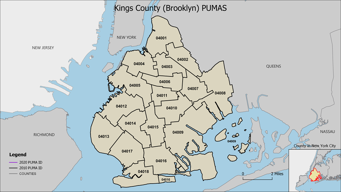

| PUMA ID | Name | Population 2020 | Housing Units 2020 |
|---|---|---|---|
| 04301 | NYC-Brooklyn Community District 1--Williamsburg & Greenpoint | 204,125 | 89,974 |
| 04302 | NYC-Brooklyn Community District 2--Downtown Brooklyn & Fort Greene | 127,650 | 65,710 |
| 04303 | NYC-Brooklyn Community District 3--Bedford-Stuyvesant | 173,842 | 72,623 |
| 04304 | NYC-Brooklyn Community District 4--Bushwick | 120,747 | 47,292 |
| 04305 | NYC-Brooklyn Community District 5--East New York & Cypress Hills | 201,682 | 72,938 |
| 04306 | NYC-Brooklyn Community District 6--Park Slope & Carroll Gardens | 116,586 | 54,684 |
| 04307 | NYC-Brooklyn Community District 7--Sunset Park & Windsor Terrace | 133,706 | 45,939 |
| 04308 | NYC-Brooklyn Community District 8--Crown Heights (North) | 108,805 | 49,731 |
| 04309 | NYC-Brooklyn Community District 9--Crown Heights (South) | 100,103 | 40,871 |
| 04310 | NYC-Brooklyn Community District 10--Bay Ridge & Dyker Heights | 134,319 | 55,045 |
| 04311 | NYC-Brooklyn Community District 11--Bensonhurst & Bath Beach | 198,527 | 71,001 |
| 04312 | NYC-Brooklyn Community District 12--Borough Park & Kensington | 210,432 | 64,309 |
| 04313 | NYC-Brooklyn Community District 13--Coney Island & Brighton Beach | 113,451 | 48,820 |
| 04314 | NYC-Brooklyn Community District 14--Flatbush & Midwood | 162,410 | 61,732 |
| 04315 | NYC-Brooklyn Community District 15--Sheepshead Bay & Gravesend (East) | 163,346 | 64,571 |
| 04316 | NYC-Brooklyn Community District 16--Ocean Hill & Brownsville | 102,095 | 38,649 |
| 04317 | NYC-Brooklyn Community District 17--East Flatbush | 160,243 | 61,364 |
| 04318 | NYC-Brooklyn Community District 18--Canarsie & Flatlands | 204,005 | 72,401 |
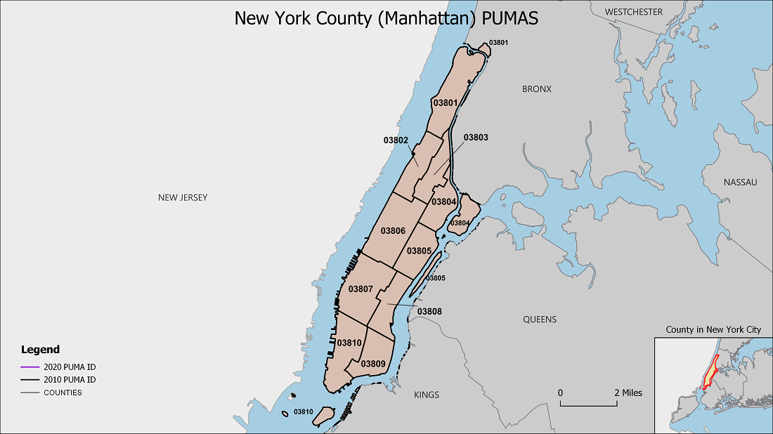

| PUMA ID | Name | Population 2020 | Housing Units 2020 |
|---|---|---|---|
| 04103 | NYC-Manhattan Community District 3--Lower East Side & Chinatown | 163,141 | 82,589 |
| 04104 | NYC-Manhattan Community District 4--Chelsea & Hells Kitchen | 129,265 | 82,889 |
| 04107 | NYC-Manhattan Community District 7--Upper West Side | 224,344 | 127,870 |
| 04108 | NYC-Manhattan Community District 8--Upper East Side & Roosevelt Island | 231,983 | 138,922 |
| 04109 | NYC-Manhattan Community District 9--Morningside Heights & Hamilton Heights | 110,458 | 44,900 |
| 04110 | NYC-Manhattan Community District 10--Harlem | 130,440 | 61,629 |
| 04111 | NYC-Manhattan Community District 11--East Harlem | 125,771 | 54,738 |
| 04112 | NYC-Manhattan Community District 12--Washington Heights & Inwood | 188,800 | 78,300 |
| 04121 | NYC-Manhattan Community Districts 1 & 2--Financial District & Greenwich Village | 170,835 | 100,395 |
| 04165 | NYC-Manhattan Community Districts 5 & 6--Midtown, East Midtown, & Flatiron | 219,214 | 141,694 |
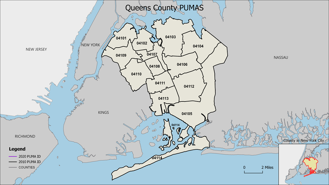
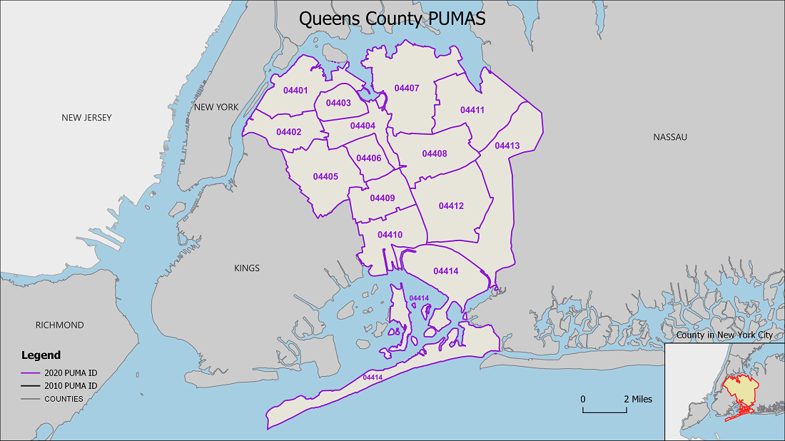
| PUMA ID | Name | Population 2020 | Housing Units 2020 |
|---|---|---|---|
| 04401 | NYC-Queens Community District 1--Astoria & Queensbridge | 193,031 | 90,546 |
| 04402 | NYC-Queens Community District 2--Long Island City, Sunnyside, & Woodside | 137,718 | 60,696 |
| 04403 | NYC-Queens Community District 3--Jackson Heights & East Elmhurst | 178,855 | 58,912 |
| 04404 | NYC-Queens Community District 4--Elmhurst & Corona | 181,730 | 58,072 |
| 04405 | NYC-Queens Community District 5--Ridgewood, Maspeth, & Middle Village | 179,294 | 69,946 |
| 04406 | NYC-Queens Community District 6--Forest Hills & Rego Park | 119,706 | 56,120 |
| 04407 | NYC-Queens Community District 7--Flushing, Murray Hill, & Whitestone | 270,930 | 103,229 |
| 04408 | NYC-Queens Community District 8--Fresh Meadows, Hillcrest, & Briarwood | 157,986 | 58,218 |
| 04409 | NYC-Queens Community District 9--Kew Gardens, Richmond Hill, & Woodhaven | 151,876 | 50,622 |
| 04410 | NYC-Queens Community District 10--South Ozone Park & Howard Beach | 130,378 | 43,508 |
| 04411 | NYC-Queens Community District 11--Auburndale, Bayside, & Douglaston | 122,366 | 47,439 |
| 04412 | NYC-Queens Community District 12--Jamaica, St. Albans, & Hollis | 257,759 | 84,633 |
| 04413 | NYC-Queens Community District 13--Queens Village, Bellerose, & Rosedale | 199,648 | 66,410 |
| 04414 | NYC-Queens Community District 14--The Rockaways | 124,187 | 47,982 |
| PUMA ID | Name | Population 2020 | Housing Units 2020 |
|---|---|---|---|
| 04501 | NYC-Staten Island Community District 1--North Shore | 189,663 | 69,066 |
| 04502 | NYC-Staten Island Community District 2--Mid-Island | 141,591 | 51,980 |
| 04503 | NYC-Staten Island Community District 3--South Shore | 164,493 | 62,646 |
| PUMA ID | Name | Population 2020 | Housing Units 2020 |
|---|---|---|---|
| 00100 | St. Lawrence County | 108,505 | 51,612 |
| 00200 | Clinton, Franklin, Essex & Hamilton Counties | 169,886 | 95,582 |
| 00500 | Jefferson & Lewis Counties | 143,303 | 77,068 |

| 2020 PUMA ID | PUMA Name | Region | Population 2020 | Housing Units 2020 |
|---|---|---|---|---|
| 2201 | Broome County (West Central)--Greater Binghamton City & Greater Johnson City Village PU | Southern Tier | 129,527 | 60,612 |
| 2204 | Chenango, Delaware Counties & Broome County outside Greater Binghamton City | Southern Tier | 160,684 | 86,120 |
| 2300 | Tompkins County | Southern Tier | 105,740 | 46,884 |
| 2403 | Tioga (South), Chemung (South) & Steuben (East) Counties--Elmira & Corning Cities | Southern Tier | 129,289 | 60,404 |
| 2404 | Steuben (outside Corning City), Schuyler, Chemung (North) & Tioga (North) Counties | Southern Tier | 114,796 | 57,316 |

| PUMA ID | Name | Population 2020 | Housing Units 2020 |
|---|---|---|---|
| 01101 | Niagara County (Southwest)--Greater Niagara Falls & North Tonawanda Area | 105,708 | 52,399 |
| 01102 | Niagara County (North & East) | 106,958 | 47,757 |
| 01201 | Erie County (Northwest) | 109,154 | 51,307 |
| 01202 | Erie County (North Central) | 129,595 | 54,435 |
| 01203 | Erie County (Northeast) | 113,381 | 48,625 |
| 01204 | Erie County (Central) | 155,326 | 73,175 |
| 01205 | Erie County (West Central)--Buffalo City (East) | 157,444 | 74,588 |
| 01206 | Erie County (West Central)--Buffalo City (West) | 120,905 | 61,762 |
| 01207 | Erie County (South) | 168,431 | 74,855 |
| 02500 | Cattaraugus & Allegany Counties | 123,498 | 63,606 |
| 02600 | Chautauqua County | 127,657 | 66,247 |