|
TiDbit 26-01 Leslie Reynolds
|
|
Emergency Care Deserts in New York State
|
|
Data and Methods
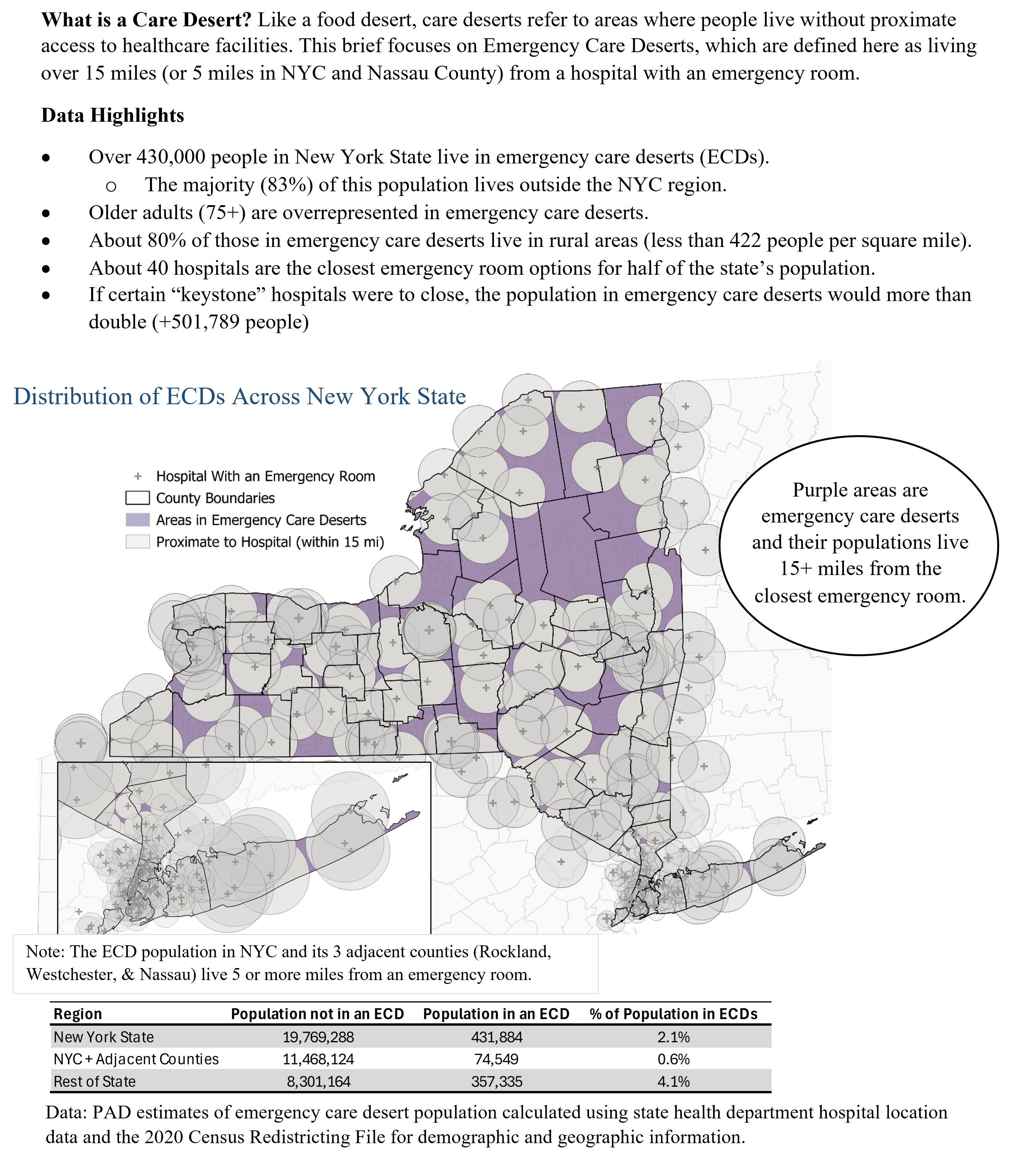
Emergency Care Deserts (ECDs) are defined as living beyond a threshold distance from the nearest emergency room. For this brief, we calculated distance buffers around each hospital according to what broad region they were located in. Though Long Island is generally considered part of the “downstate” region, Nassau County is more similar in density to the rest of downstate than Suffolk County is. Therefore, hospitals in NYC and its adjacent counties (Westchester, Rockland, and Nassau) were given radii of 5 miles, while the rest of the state (including Suffolk County) were given radii of 15 miles. This approach is more conservative and less granular for NYC than the USDA proposes for the calculation of food deserts (USDA, 2026), but since these brief focuses on the entire state and NYC is not uniform in its urbanicity, we expanded the distance of the downstate buffer from 1 mile to 5. Three of the four hospitals in Connecticut were considered a special case due to their proximity to NYC, so their radii were adjusted down to 10 miles. To determine the population living in emergency care deserts, block group population data from the 2020 Census Redistricting File (PL 94-171) was obtained along with the 2020 block group boundary file to map population across New York State. The radii were intersected with the block group population to identify areas on the map not covered by circles on the map. For block groups that were only partially within an ECD, the population was allocated proportionally based on the share of block group area located within the uncovered zone, using this formula:

This approach is limited in that it assumes population is evenly distributed within each block group, which in reality is very rare, but is appropriate for a basic estimate.
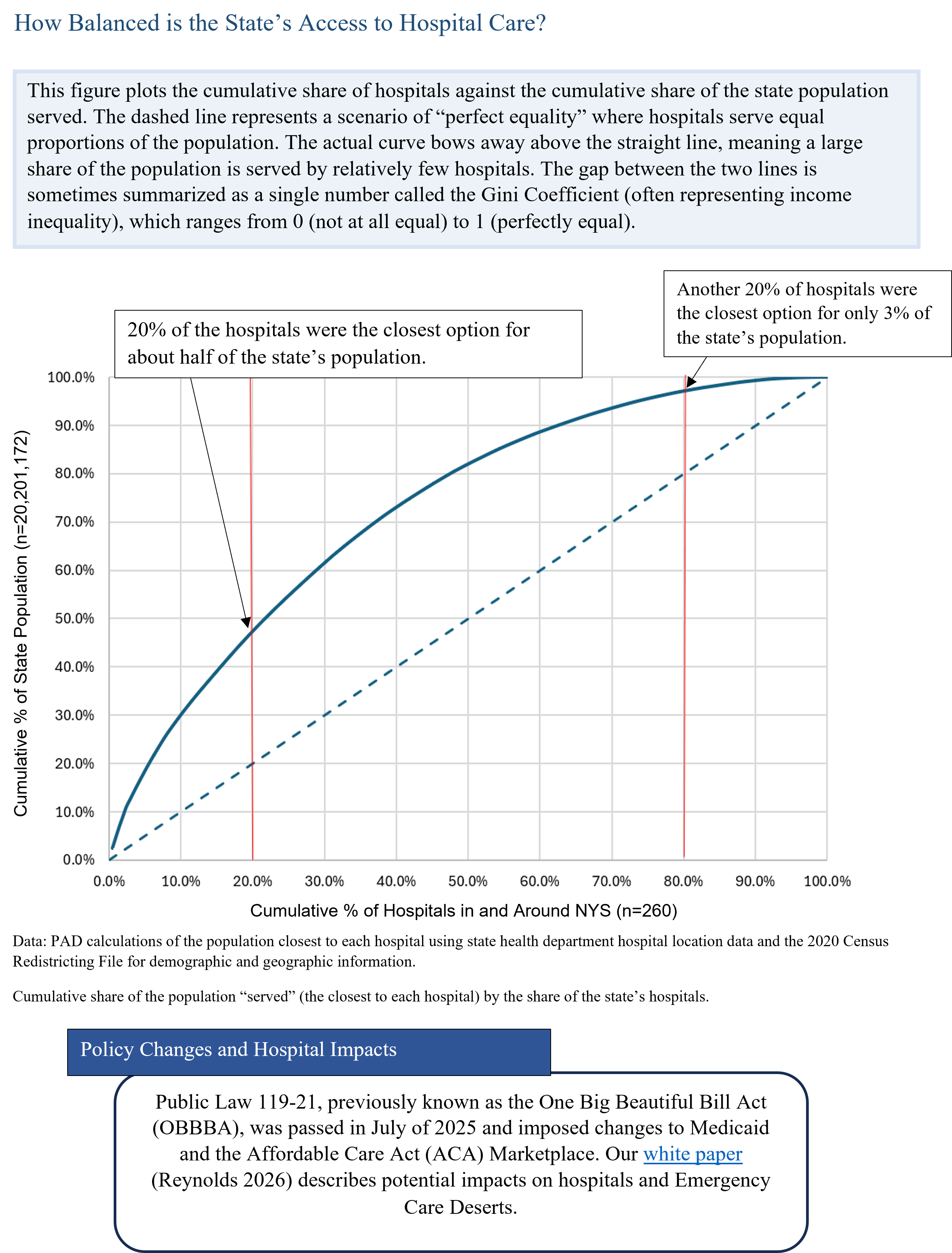
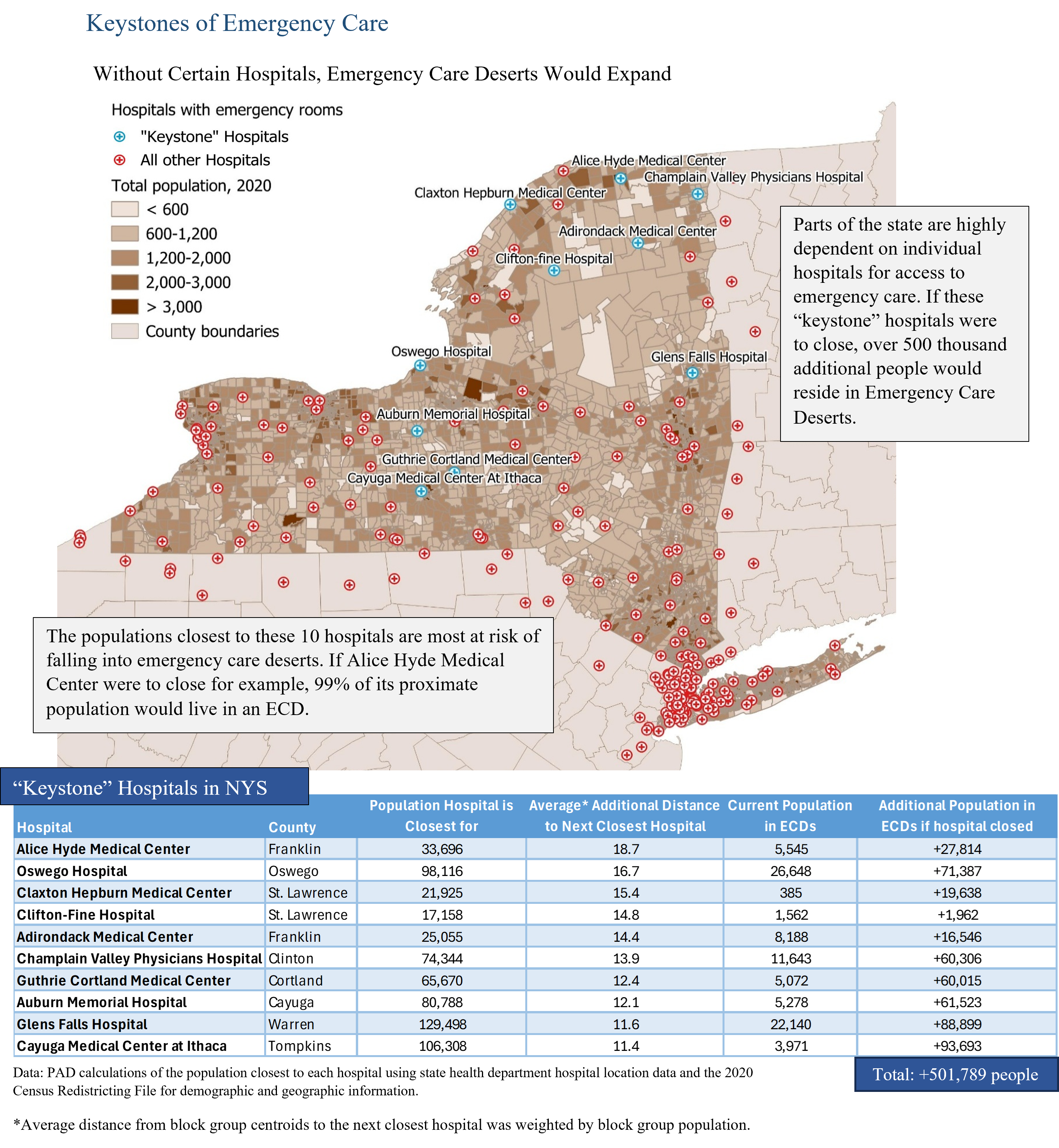
To calculate the closest hospital to a block group, the distances between each block group centroid and their three closest hospitals were calculated using an Origin-Destination Matrix. This is an “as the crow flies” method and does not account for geographic barriers, road networks, traffic, or terrain. This approach is likely to underestimate rather than overestimate care deserts, as these constraints should increase the distance or time needed to travel to an emergency room. More information on the ECD methodology used here and further details on our estimation of hospital closure impacts can be found in our white paper (Reynolds, 2026).
|
|
|
|
About the Author
Leslie Reynolds is a Research Support Specialist at the Cornell University Program on Applied Demographics (PAD). In her work, she uses a multitude of data sources to study population dynamics and trends across New York State and beyond.
PAD is the applied population group within the Cornell Population Center (CPC) and a coordinating agency of the New York State Data Center (NYSDC). PAD combines skills in demographics, statistics, data gathering and analysis to track population trends and patterns, evaluate data quality and methodological impacts, and assist various organizations with data retrieval and analysis needs.
|
|
|
References
Congressional Budget Office (CBO). 2025. “Estimated Budgetary Effects of Public Law 119-21, to Provide for Reconciliation Pursuant to Title II of H. Con. Res. 14, Relative to CBO’s January 2025 Baseline,” webpage, July 21, 22025. As of December 30, 2025: https://www.cbo.gov/publication/61570
Nguyen, Amanda & Lauren Chase. 2025. “Mapping Healthcare Deserts: Over 80% of the Country Still Lacks Adequate Access to Care”. https://www.goodrx.com/healthcareaccess/research/updated-healthcare-deserts
Rao, Preethi, Lawrence Baker, Federico Girosi, Elaine Li, Rose Kerber, and Christine Eibner. 2026. “State-Level Impacts of Key Medicaid Provisions in the One Big Beautiful Bill Act”. RAND Corporation, RR-A4098-1. As of April 13, 2026: https://www.rand.org/pubs/research_reports/RRA4098-1.html
Reynolds, Leslie. 2026. “Access Denies: Hospital Closures and Emergency Care Deserts in New York State”. Cornell University Program on Applied Demographics (PAD). https://pad.human.cornell.edu/papers/downloads/HospitalClosures.pdf
United States Department of Agriculture (USDA). 2026. “Food Access Research Atlas”. https://www.ers.usda.gov/data-products/food-access-research-atlas/go-to-the-atlas
|
|
|
|
|